masthead-bg

Geospatial

Geospatial-Main
Geospatial-Accent

Data Integration and Management

Data Matters

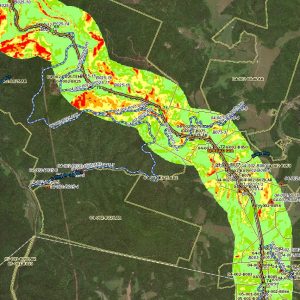
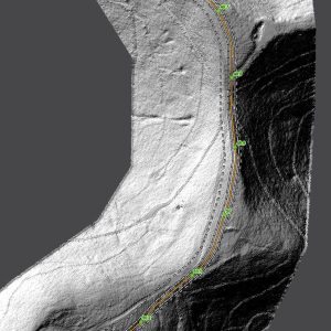
The Gulf Geospatial Services Group provides innovative solutions for our clients’ data management needs. We gather and analyze data using the latest GIS technology to provide support to our clients for timely and accurate decisions.

  • Highly experienced, efficient, creative, innovative with a client-centric attitude
  • Fit-for-purpose solutions for each client
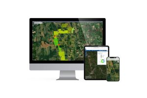
  • Easy and intuitive web-based and mobile spatial solutions that promote collaboration and efficient decision making
  • Transparent and efficient processes
  • Comprehensive data integration and management
  • Scalable – small to mega projects

Contact Us

Transparent & Efficient Processes

The Gulf Geospatial Services

tab-accordion-bg-icon

Leading Edge GIS Analytic Tools

  • Qualitative routing and site selection process
  • Quantitative Environmental impact assessments
  • Reliable Geohazards identification
  • Enhanced support of land acquisition & survey
  • Improved regulatory agency interactions
  • Improved quality of drawings and maps

Geospatial Viewers

  • Collaborative data-driven geospatial viewer
  • Dashboards for “at a glance” management assessments
  • Spatially linked drawings, 3D models and photos
  • Intuitive menus / online tutorials
  • Works on any device – Windows, Mac, iOS, Android

Mobile Solutions

  • Standard or Custom mobile solutions
  • Online or Offline functionality
  • Near real-time access to data
  • Data centrally stored & always accessible

Data Management

  • Secured central database of all the spatial data
  • Utility network models to bridge the gaps between assets
  • Enables merging assets with different GIS data models
CONTACT US

We’d love to hear from you.

(713) 850-3400 CONTACT US

background-map